- 主頁 /
- 電子產品 /
- 汽車和車載電子產品 /
- Marine Electronics /
- Marine GPS Chartplotters /
- Weems & Plath Marine Navigation GPS Plotter
0 ratings


商品#:
25178446
Weems & Plath Marine Navigation GPS Plotter
商品#:
25178446
TWD 3164
Price Details
Excluding Shipping & Custom charges ( Shipping and custom charges will be calculated on checkout )
*All items will import from 美國
0 ratings
撰寫評論
有存貨
QTY:
庫存僅剩7件。
立即訂購並活動它 Sunday, 六月 28
Secured transaction
Ubuy works hard to protect your security and privacy. Our advanced payment security system ensures confidentiality by encrypting your information during transmission using AES (Advanced Encryption Standards) and SSL (Secure Socket Layer) protocols. Your payment details are 100% secure as we do not share your payment details with third party sellers.
Our Top Logistics Partners
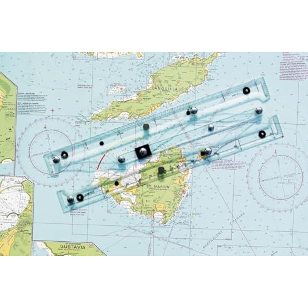
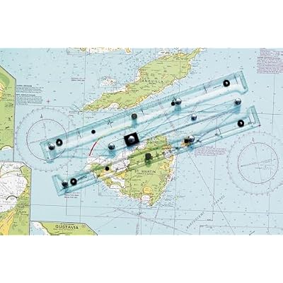
Quickly, easily, and accurately plot your GPS coordinates on a paper chart with our GPS Plotter.
Fast
Shipping
Free
Return*
Secure Packaging
100% Original Products
PCI DSS Compliance

ISO 27001 Certified
產品詳情
- 15-1/2 inches (39.37cm) long
- Innovative straight-line action
- Pencil guide holes
- Sturdy clear acrylic & stainless steel/brass construction
- Non-slip pads
- Protractor & parallel rule features
- Instructions on back of protective plastic sleeve
| Compatible with Vehicle Type | Boat |
| Additional Features | Effective Interface |
| Map Types | Nautical |
| Mounting Type | Panel Mount |
| Touch Screen Type | Resistive |
| Display Type | touch screen |
| Human-Interface Input | Buttons |
| Compatible Devices | Smartphone, Tablet |
| Control Method | Touch |
| Are Batteries Included | No |
| Supported Satellite Navigation System | GPS |
| Sport Type | Boating |
| Brand | WEEMS-AND-PLATH |
| Model Name | 130 |
| UPC | 721002001849 |
| Global Trade Identification Number | 00721002001849 |
| Manufacturer | Weems & Plath |
| Model Number | 130 |
| Mfr Part Number | 130 |
| Item Dimensions L x W x H | 15.5"L x 3"W x 0.66"H (39.4 x 7.6 x 1.7 cm) |
| Item Weight | 1.3 Pounds (590 grams) |
| Vehicle Service Type | Boat |
| Special Feature | Effective Interface |
| Map Type | Nautical |
| Product Dimensions (L x W x H) | 15.5"L x 3"W x 0.66"H (39.4 x 7.6 x 1.7 cm) |
產品描述
有疑問? 和我們聊天
客戶問答
-
問題:
What features does the Weems & Plath Marine Navigation GPS Plotter offer?
Answer: The Weems & Plath Marine Navigation GPS Plotter boasts advanced features such as precise GPS tracking, easy-to-read display options, and customizable waypoints. Designed for marine navigation, this plotter helps sailors navigate with confidence by providing clear maps and real-time positioning data. With integrated tools for route planning, users can chart their course effectively, making it a valuable asset for both recreational boaters and professional mariners. -
問題:
Is the Weems & Plath Marine Navigation GPS Plotter user-friendly?
Answer: Yes, the user interface of the Weems & Plath Marine Navigation GPS Plotter is designed to be intuitive and accessible even for novice users. The touch screen feature allows for easy navigation through menus and settings, which is essential when out at sea. This GPS plotter has customizable display options, making it suitable for various lighting conditions, and ensuring that all users can operate it with minimal training. -
問題:
Can the Weems & Plath GPS Plotter provide real-time weather updates?
Answer: The Weems & Plath Marine Navigation GPS Plotter does not inherently provide real-time weather updates; however, it can integrate with compatible devices or apps that do. The importance of weather conditions cannot be overstated in marine environments, and by connecting to weather services, users can monitor changes and make informed decisions during their voyages, enhancing safety on the water. -
問題:
What types of maps does the Weems & Plath GPS Plotter support?
Answer: The Weems & Plath Marine Navigation GPS Plotter supports various maritime map types, including vector charts and raster charts. This flexibility ensures users can access the most relevant and up-to-date navigational information for their specific sailing area. Many boaters prefer vector charts for their accuracy and detail, while raster charts provide historical data, catering to diverse navigational needs. -
問題:
How does the Weems & Plath GPS Plotter assist in route planning?
Answer: The Weems & Plath Marine Navigation GPS Plotter simplifies route planning by allowing users to set waypoints and create paths directly on its interface. The plotting software can calculate the distance and estimated travel time, enabling sailors to plan their journeys more effectively. This capability is crucial for long-distance voyages, where precise navigation can make all the difference in safety and efficiency. -
問題:
What is the battery life of the Weems & Plath Marine Navigation GPS Plotter?
Answer: The battery life of the Weems & Plath Marine Navigation GPS Plotter is designed to support extended use without interruption. While specifics can vary based on operational settings, users typically find the battery performs well for prolonged periods, making it suitable for day trips or longer excursions. Ensuring that the device is adequately charged before setting out is essential for continuous navigation and access to critical information while on the water. -
問題:
Can I use the Weems & Plath GPS Plotter for both inland and offshore navigation?
Answer: Yes, the Weems & Plath Marine Navigation GPS Plotter is versatile enough for both inland and offshore navigation. Its comprehensive mapping capabilities allow users to navigate various waterways confidently. This multifunctionality makes it ideal for recreational boaters who explore lakes and rivers as well as for those sailing in coastal environments, ensuring reliable performance in diverse settings. -
問題:
Does the Weems & Plath GPS Plotter support Bluetooth connectivity?
Answer: The Weems & Plath Marine Navigation GPS Plotter typically does not include Bluetooth connectivity, focusing instead on providing reliable GPS navigation without additional wireless features. Nonetheless, it can connect to external devices such as AIS transponders for better situational awareness. This ensures that every boater has the tools needed to stay informed about other vessels in the vicinity while navigating. -
問題:
Are updates available for the Weems & Plath Marine Navigation GPS Plotter?
Answer: Yes, users can access updates for the Weems & Plath Marine Navigation GPS Plotter to enhance functionality and support newer navigation technologies. Keeping the software up to date is crucial for ensuring optimal performance and access to the latest maritime charts. Regular updates can improve features and provide usability enhancements, making it a reliable tool for any maritime journey. -
問題:
Where can I buy the Weems & Plath Marine Navigation GPS Plotter in Taiwan?
Answer: You can purchase the Weems & Plath Marine Navigation GPS Plotter in Taiwan at Ubuy. Ubuy offers a reliable online platform where you can find this product and have it delivered straight to your location, ensuring easy access for all your navigation needs.
WEEMS&PLATH Marine GPS Chartplotters 130 Editorial Review
The Weems & Plath Marine Navigation GPS Plotter offers a great concept, but falls short in terms of construction quality. The arms and hinge points that establish the parallels are flimsy and fail to maintain accurate navigation. Although it is good enough for general area navigation, it is not suitable for specific location accuracy. Some units have arrived with missing support-feet and slight twists, while others have issues with misaligned ruler markings and unreadable instructions. The responsibility for these faults lies with the manufacturer, Weems & Plath, as the quality of their packaging and the misaligned markers are a result of their Q&A department. Despite these flaws, the product functions as listed and some customers would consider buying it again.
Customer Reviews & Ratings
9 客戶評價
-
5 星
61%
-
4 星
10%
-
3 星
17%
-
2 星
0%
-
1 星
12%
評論這個產品
和其他客戶分享您的想法
優點
- Great concept
- Functions as listed
- Arrived on time
缺點
- Flimsy construction
Product Price History
重要資訊
- 限制:對於國際運輸的產品,請注意任何製造商保修可能無效;製造商服務選項可能不可用;產品手冊、說明和安全警告可能不是目的地國家的語言;產品(及隨附材料)的設計可能不符合目的地國家的標準、規範和標籤要求;並且產品可能不符合目的地國家的電壓和其他電氣標準(如果適用,需要使用適配器或轉換器)。收件人有責任確保產品可以合法進口到目的地國家。當從Ubuy或其關聯公司訂購時,收件人是記錄在案的進口人,並且必須遵守目的地國家的所有法律和法規。
- 由於Ubuy是一個全球搜索引擎,因此並非Ubuy上列出的所有產品都在出售。產品受出口/貿易法規的約束。
TWD 3164
立即訂購並活動它 Sunday, 六月 28
This item is not restrict in my country.(Please click on above link if this item is not restrict in your country, So our team will review and allow.)
QTY:
庫存僅剩7件。
Secured transaction
Ubuy works hard to protect your security and privacy. Our advanced payment security system ensures confidentiality by encrypting your information during transmission using AES (Advanced Encryption Standards) and SSL (Secure Socket Layer) protocols. Your payment details are 100% secure as we do not share your payment details with third party sellers.
Our Top Logistics Partners
Fastest cross-border delivery
特色和優勢
- Simplified two-step maneuver for plotting GPS coordinates.
- Compatible with any paper chart for versatile use.
- Designed for accuracy in latitude and longitude plotting.
- User-friendly interface for anyone, regardless of experience.
- Enhances traditional navigation methods with modern technology.
- Essential tool for sailors and outdoor enthusiasts.